Home / Sample report
Sample premium report · as of November 13, 2026
27 Larkspur Hollow Road
Simsbury, CT 06070
- Zone R-40
- 1.85 acres
- Residential
Property basics
Parcel map
The parcel (highlighted), buildings and neighboring lot lines from town and state GIS data, as of the report date. Lot lines are approximate, not a survey.
Parcel
- Parcel ID
- Sample
- Zone
- R-40
- Land use
- Residential
- Acres
- 1.85
Building
- Year built
- 1987
- Living area
- 2,468 sq ft
- Rooms
- 8
- Bedrooms
- 4
- Baths
- 2 full, 1 half
Assessed value (2025)
- Total
- $371,000
- Land
- $127,610
- Building
- $243,390
Appraised value (2025)
- Total
- $530,000
- Land
- $182,300
- Building
- $341,500
- Outbuildings
- $6,200
The town’s estimate of market value. Assessed value is 70% of it, except where land qualifies for a reduced farm, forest or open-space assessment.
Recent filings nearby
- Zoning variance: 14 Wren Hollow Lane
- Wetland permit: Quill Pond Road
- Special permit or site plan: Larkspur Hollow Road Informal
Filings within 1 mile from town meeting agendas posted in the 90 days before this report, including upcoming meetings. Add this property to your watchlist to get alerts about new filings.
Ownership & sale
Owner of record
- Owner
- JORDAN SAMPLE
- Co-owner
- TAYLOR SAMPLE
- Mailing address
- 27 LARKSPUR HOLLOW ROAD, SIMSBURY, CT 06070
From the town’s assessor records; the owner of record can lag behind recent sales.
Most recent sale
- Sale date
- 06/14/2019
- Sale price
- $412,500
From the town’s assessor records.
Water & flood
Flood risk & insurance
- In FEMA’s high-risk flood zone?
- Yes. 67.6% of the property is in FEMA’s high-risk flood zone.
- Any building in the high-risk zone?
- Yes: 1 of 2 buildings touch it
- Zones the buildings touch
- High risk (Zone A)
- Buildings in the floodway
- None
- Most of one building in the zone
- All of at least one building
- Is flood insurance required?
- Likely: a building touches the high-risk zone, and federally regulated or insured lenders (most mortgages) require flood insurance for it.
- FEMA letters for this property (LOMA)
- 08/20/2019: Request denied: the building stays in the high-risk zone (Letter of Map Amendment 00-01-0000A)
- Status of those letters
- Issued under earlier flood maps. They apply to the maps effective 11/13/2026 only if FEMA revalidated them; your lender or FEMA can confirm.
- Highest-risk flood zone on the property
- High risk (Zone A): a 1% chance of flooding each year (about 1 in 4 over a 30-year mortgage); flood heights not studied in detail
- Flood zones across the property
- High risk (Zone A): 67.6%
- Minimal risk (Zone X): 27.4%
- Moderate risk (shaded Zone X): 4.9%
- Flood height (base flood elevation)
- Not published: FEMA hasn’t studied flood heights for Zone A areas. A surveyor can estimate one.
- Flood insurance claims in the area
- 9 claims within the surrounding area (census tract), not necessarily at this property
- Flood maps in effect since
- 11/13/2026
- FEMA map panels
- 09003C0188G
From FEMA flood maps. Lenders decide based on whether the building is in a high-risk zone, so part of the land being in one doesn’t always mean insurance is required. An Elevation Certificate from a licensed surveyor, or a FEMA Letter of Map Amendment, can settle it. Outside high-risk zones, a lender can still ask for flood insurance, and it’s usually cheaper there. Flood height is how high water is expected to rise in a 1%-a-year flood: the higher the lowest floor sits above it, the lower the risk and usually the premium. FEMA letters are FEMA’s official decisions on whether a building or lot is in the high-risk zone; new flood maps can supersede older letters. Buildings are from Connecticut’s building footprints; a building counts if any part of it touches the high-risk zone (Zone A, AE or the floodway, not Zone X). Flood insurance claims are FEMA’s count of National Flood Insurance Program claims for the surrounding census tract; they don’t say whether this property has flooded.
FEMA’s proposed flood maps (preliminary, not in effect)
- Preliminary flood map changes
- No preliminary flood maps at this time.
Wetlands
- Wetlands on the parcel
- Yes
- Share of the parcel
- 44.5%
- Wetland types
- Freshwater Forested/Shrub Wetland (44.5%)
Elevation
- Average
- 294 ft
- Lowest point
- 291 ft
- Highest point
- 307 ft
Water, sewer & septic
- Public water
- Public water likely available
- Water system
- Tariffville Fire District Water Dept
- Sewer
- In sewer service area
- Sewage treatment plant
- Simsbury
From state and EPA service-area maps. Being inside a service area doesn’t guarantee the house is connected; the town or the seller can confirm. Without public water or sewer, a property usually relies on a private well or a septic system.
Aquifer protection area
- In an aquifer protection area?
- Yes, 64% of the property
- Protected well field
- Tariffville (Tariffville Fire District Water Department)
Aquifer protection areas surround public water-supply wells (CT DEEP). Connecticut regulates certain business activities in them, such as storing large amounts of fuel or chemicals; most household uses aren’t affected.
Land & environment
Slope & buildable ground
- Average slope
- 8.7% (moderate)
- Steeper than 15%
- 18% of the parcel
- Steeper than 25%
- 4.1% of the parcel
- Easier-to-build ground
- 1.46 acres (82% of the parcel)
- Slopes mostly face
- West
- Facing the sun (southeast to southwest)
- 26.7% of the parcel
From USGS lidar elevation data. Zoning and septic rules often get stricter on slopes over 15%, and slopes over 25% are hard to build on without major grading. Easier-to-build ground is gently sloped (15% or less) and outside wetlands and FEMA’s current high-risk flood zone; zoning setbacks aren’t considered.
Soils
- Soils across the parcel
- Wilbraham silt loam 65%
- Rainbow silt loam 25%
- and other soils
- Hydrologic soil group
- C/D: Soaks in slowly where drained; otherwise barely soaks in (high water table)
Soils and hydrologic soil groups are from the USDA Natural Resources Conservation Service soil survey (SSURGO). Hydrologic soil groups rate how fast water soaks in when the soil is already wet. Soil maps are drawn for large areas, so conditions on a specific lot can differ; an on-site soil test, such as the one done for a septic system, gives the real answer.
Radon potential
- Level
- Low
- What it means
- Average indoor radon likely below 2 pCi/L. Testing still advised.
From the U.S. Geological Survey’s geologic radon potential map (2025). It rates the rock and soil of the area, not this home: radon levels vary a lot from house to house, even next door, depending on the foundation, ventilation and how the house is used. A low rating doesn’t mean a home is radon-free. The only way to know is to test; the EPA recommends testing every home and fixing it at 4 pCi/L or above.
Transportation noise
- Noise level
- Moderate: noticeable traffic or aircraft noise
- Loudest spot, all transportation
- 57 dBA
- Road traffic
- 57 dBA
- Aircraft
- 45 dBA or less (background level)
Modeled 24-hour averages from the U.S. DOT National Transportation Noise Map (2020) at the loudest spot on the parcel, not measurements. For comparison, normal conversation is about 60 dBA; 65 dBA is the level federal agencies treat as a noise impact.
Contaminated or potentially contaminated sites within 1 mile
- Sites
- 4
- Open cases
- 3
- Closed cases
- 1
From the Connecticut Department of Energy and Environmental Protection (CT DEEP) list of contaminated or potentially contaminated sites, measured from the property line. Open cases counts sites with at least one case still open; closed cases counts sites whose cases are all resolved or withdrawn. Being on the list doesn’t mean contamination has spread beyond a site, and many sites are only being investigated. Distance alone doesn’t tell you the risk to this property.
EPA-regulated facilities within 1 mile
- Facilities
- 2
- With recent violations
- 1
- Facilities with violations
- ETHEL WALKER SCHOOL
From the EPA’s Facility Registry Service and ECHO compliance data, measured from the property line. Many everyday businesses are registered, such as gas stations, auto shops, dry cleaners, farms and schools. Recent violations means at least one quarter in violation in the last 3 years; some are paperwork or reporting issues rather than releases. Details for each facility are on EPA’s ECHO website (echo.epa.gov).
Natural hazard risk (FEMA National Risk Index, census tract)
- Overall
- Low risk
- Inland flooding
- Moderate risk
- Strong wind
- Low risk
- Hurricane
- Low risk
- Tornado
- Low risk
- Winter weather
- Low risk
- Ice storm
- Low risk
- Cold wave
- Moderate risk
- Heat wave
- Low risk
- Hail
- Low risk
- Lightning
- Low risk
- Drought
- Very low risk
- Wildfire
- Very low risk
- Landslide
- Very low risk
- Earthquake
- Very low risk
Neighborhood & infrastructure
Public safety
- Registered sex offenders within 5 miles
- 12
Count from Connecticut’s public sex offender registry (portal.ct.gov/dess) as of the report date. Misusing registry information to harass or harm anyone is against the law.
Schools
- School district
- Simsbury School District
- Elementary
- Tariffville School (K-6)
- Middle
- Henry James Memorial School (7-8)
- High
- Simsbury High School (9-12)
Simsbury’s assigned schools come from a federal attendance-zone survey (NCES, 2015–16); Granby’s follow the district’s current setup, where every student attends the same schools. Confirm current assignments with the school district.
Historic districts & sites
- National Register historic district
- Terry's Plain Historic District
- Individually listed on the National Register
- Humphrey, John, House
Cell service
- Number of carriers with coverage
- 4 of 4
- Number with 5G
- 3 of 4
- Carriers with coverage
- AT&T
- T-Mobile
- Verizon
- Boost Mobile (DISH)
What carriers report to the FCC; coverage indoors is often weaker than outdoors.
Broadband
- Internet providers
- 7
- All providers
- Frontier (wired)
- HughesNet
- Starlink
- T-Mobile
- Verizon
- Viasat Inc
- Xfinity (wired)
Travel time to key places
- Nearest transit
- Bus stop
- Travel time
- 3–7 min
- Nearest supermarket
- Big Y
- Travel time
- 3–7 min
- Nearest fire station
- Simsbury Tariffville Fire Department
- Travel time
- 2–6 min
- Nearest police station
- Simsbury Police
- Travel time
- 4–8 min
- Nearest hospital
- Saint Francis Hospital and Medical Center
- Travel time
- 19–23 min
- Nearest airport
- Bradley International Airport
- Travel time
- 17–21 min
Travel time to cities
- Hartford
- 19–23 min
- East Hartford
- 21–25 min
- New Britain
- 29–33 min
- Torrington
- 30–34 min
- Westfield, MA
- 28–32 min
- West Springfield, MA
- 30–34 min
- Springfield, MA
- 30–34 min
- Middletown
- 36–40 min
- Meriden
- 40–44 min
- Waterbury
- 42–46 min
- New Haven
- 56–60 min
Cities within a 60-minute drive. Drive times are estimates for normal speeds without traffic.
Energy infrastructure
- Transmission line within 1 mile
- Yes
- Distance to nearest transmission line
- 1,398 ft
- Substation within 1 mile
- Yes (1)
- Wind or solar farm within 1 mile
- Yes (1)
- Nearest wind or solar farm
- Solar farm - Tobacco Valley Solar (4797 ft)
FAA obstructions
- Obstructions within 1 mile
- 24
- Tallest, height above ground
- 202 ft
Historical aerial photos
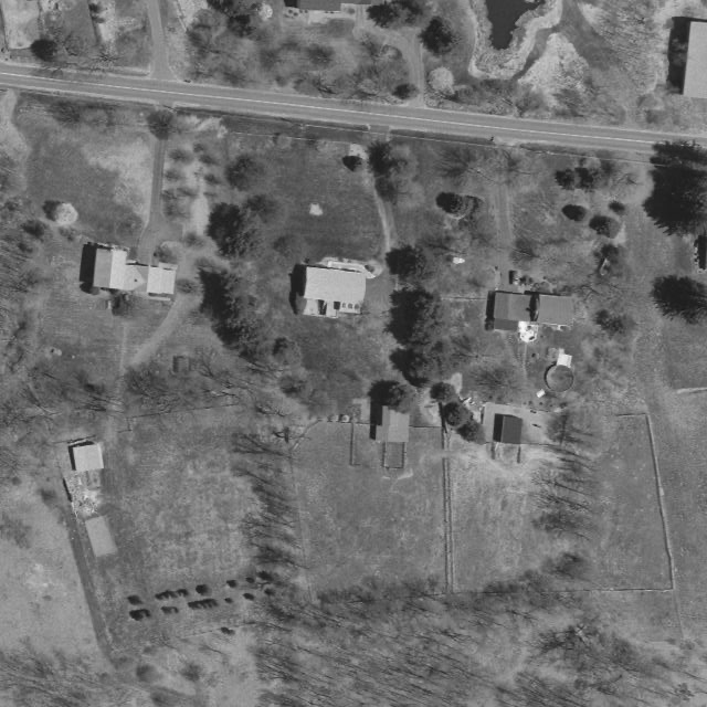
This photo couldn’t be loaded right now. Refresh the page to try again.
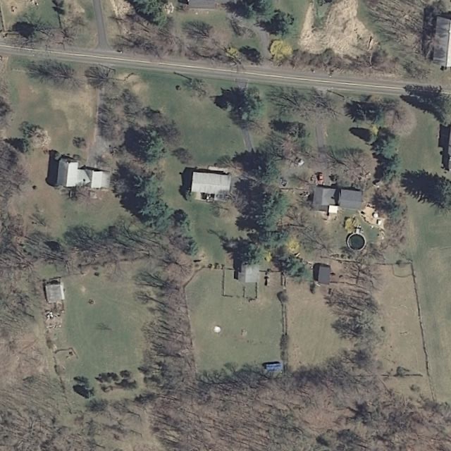
This photo couldn’t be loaded right now. Refresh the page to try again.
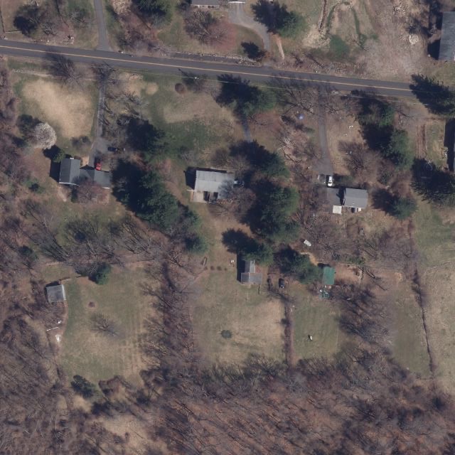
This photo couldn’t be loaded right now. Refresh the page to try again.
The property outlined in amber, on the same view as the parcel map above. The photos are taken in spring, before the leaves come out; 2004 is black and white. Statewide spring aerial photos from the Connecticut State GIS Office and CT ECO (UConn CLEAR).
Get a report for a real property
Create a free account, find any Simsbury or Granby property on the map, and get its premium report for $20, or 5 for $85.
Disclaimer: PlotAware compiles information from public records and third-party sources for general informational purposes only. It is not an official zoning determination, legal advice, survey, appraisal or title report, and it may be incomplete, delayed or inaccurate. PlotAware is not affiliated with any town, city or government agency. Always confirm information with the appropriate municipal office or a qualified professional before making decisions or taking action.